This article urges the use of technology and well proven methods to improve ground investigation outcomes and to facilitate digital geotechnical information to target risk. The benefit is well proven to ground engineering project cost and schedule.
This third in our series concerning ground investigation, talks about using digital data gathering methods and techniques to improve on ground investigation schedule and reduce contractor risk. Geophysical methods being digitally based can be deployed to improve the speed of investigation, quality and relevance of information for use in digital models.
Digital Information
For Developers and Contractors, repeatable, quality assured digital datadatsets provide an unequivocal record of conditions, readily stored in digital platforms accessed from any number of Apps, and trainable to AI.
Geophysical and insitu measurements collated in digital format, together provide factual information not reliant on qualitative observations open to interpretation. Digital data can be readily integrated into design models for efficient ground modelling and 3D mine and civil design.
For Asset Owners the same datasets serve as repeatable measurements of baseline conditions for contract management and asset lifecycle tracking.
Fast Moving Change
In an ever increasing technological world moving at faster rates but with a generally shrinking pool of skilled and experienced technical practioners, there is a looming significant difficulty to execute on projects in a timely manner.
In addition, current generation geotechnical data gathering in the Philippines with the exception of a selected few contractors, remains negatively affected by poor performance in recovery and schedule. The data is analogue and requires interpretation of description and data gaps to use with any degree of confidence.
Industry thinking of the traditional approach of drill + test needs to change.
Not All Investigators are Equal
RDCL are experts in ground investigation and modelling. The selection of the appropriate technique and the sequence of ground investigation deployment has a big influence on cost, suitability of information, early use of preliminary data, and efficiency of investigation.
Early engagement with specialist contractors offer significant benefits to the client.
Specialist contractors have special skills and experience to benefit the job. Ground investigation involves well proven technique, but which are often poorly understood outside of specialist geotechnical practitioners.
Ground investigation budgets at Planning phase can be better targeted using digital ground data integrated into asset or project models, to allow realistic assessment of risk. This means correct techniques and methods can be deployed on a targeted basis to control cost and schedules.
An Example Remote Road Alignment
RDCL was able to fast track option assessment and mitigation using geophysical techniques applied and modeling during disaster response to Cyclone Gabrielle damage within the Tararua District, New Zealand. The work enabled rapid road condition risk assessment, investigation targeting and remediation design.
An RDCL Senior Geotechnical Professional developed the investigation plan through a structured approach beginning from geomorphological overview and large-scale evaluation of risk. Site investigations were chosen beginning with Geophysical Survey including Resistivity and Seismic methods. Both methods are excellent for screening and importantly produce digital data.
Geophysics data interpreted with leading software Leapfrog against the digital terrain model including the road alignment, revealed areas with soft (blue) and hard (red) foundations and previously unrecognized landslides.
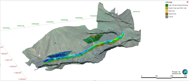
The Engineering advantage is to enable appropriate preliminary scoping of likely remedial works and to target further investigation to meet those demands.
A deliberate digital ground investigation has the potential to search for previously unrecognized unknowns, allows informed decision making in a timely manner to infill gaps in project knowledge. Digital sharing drives Collaboration which leads to speed and efficiency.
Geophysical and Insitu Testing
Surface and downhole geophysical surveys can cover large areas and penetrate below surface to provide a valuable insight into potential ground conditions and risk. All of the information is digital, repeatable and Quality Assured.
Surface geophysics provides rapid, repeatable measurements of geotechnical properties including, ground strength, density, modulus of deformation, Vs30 and groundwater conditions. These parameters are relevant to design and physical evaluation of landslides, mitigation solutions subgrade modulus and seismic site class.
Downhole geophysics including accurate measurement of geological structures and identification of geological and geotechnical zones of influence by televiewers, shear wave velocity, density and other techniques drastically improve the value of drilling.
Critically, downhole logging significantly reduces the need for manual drilling supervision, subjective core logging and processing by capturing digital data within a tailored database for geological and geotechnical modelling using modern 3D interpretive software.
The outcome is deeper insight into clients’ needs, and options to improve outcomes.
Talk To Us
Partner with us and take action at the time when it is most impactful to your project.
Contact us today.
Cam Wylie, Director, RDCL
Cam Wylie is the Managing Director, CEO & Principal Engineer at RDCL Limited. With 30 years in the industry, Cam is a Chartered Professional Engineer with extensive overseas experience, working on major projects in the Philippines, Indonesia, Africa, Australia, and New Zealand. His expertise includes Project Management, Geotechnical/Dam Engineering, Mining, Roading, Infrastructure, large subdivisions, and Residential Dwellings, and he is a contributor to the Hawke’s Bay Cyclone Gabrielle Engineering Leadership Group.