As the Philippine mining industry continues to evolve, companies are increasingly seeking technologies that can improve productivity, enhance safety, and provide accurate data for critical decision-making. Modern mining operations require more than traditional survey methods. They demand intelligent solutions that can capture, process, and deliver reliable information quickly and efficiently.
Recognizing these industry needs, QES Technology Philippines Inc. has strengthened its position as a trusted provider of geospatial and mining solutions through its portfolio of CHCNAV and GeoMate solutions. By offering advanced surveying, mapping, positioning, and monitoring technologies, QES enables mining companies to improve operational efficiency, enhance workplace safety, and make informed decisions based on accurate and reliable data.
Bringing Global Technology to Philippine Mining
Mining projects face numerous challenges, including difficult terrain, strict safety requirements, environmental monitoring, and the need for accurate operational reporting. To address these challenges, mining companies are increasingly adopting advanced geospatial technologies that enable them to collect high-quality data faster and safer than ever before.
Through QES Technology Philippines, mining organizations can leverage a comprehensive portfolio of CHCNAV and GeoMate solutions, ranging from drone-based LiDAR mapping systems and GNSS receivers to laser scanners, hydrographic survey equipment, ground monitoring technologies, and geospatial software. These solutions help improve operational efficiency, enhance safety, and reduce time spent in the field while ensuring accurate and reliable data collection.
Whether for topographic surveys, mine site mapping, stockpile volume calculations, environmental compliance, infrastructure monitoring, or exploration activities, QES delivers the technologies and technical expertise needed to support mining operations across the country.
About CHCNAV Solutions
Founded in 2003, CHC Navigation (CHCNAV) is a global leader in geospatial, positioning, and navigation technologies. Headquartered in Shanghai, China, CHCNAV develops innovative solutions for surveying, mapping, mining, construction, marine, and agriculture industries. With operations in more than 140 countries and a reputation for delivering high-precision and cost-effective technologies, CHCNAV continues to support organizations worldwide in improving efficiency, safety, and data-driven decision-making. As an authorized CHCNAV distributor in the Philippines, QES Technology Philippines Inc. provides local industries with access to CHCNAV's advanced portfolio of GNSS, LiDAR, UAV, laser scanning, hydrographic, and monitoring solutions, backed by professional technical support and after-sales service.
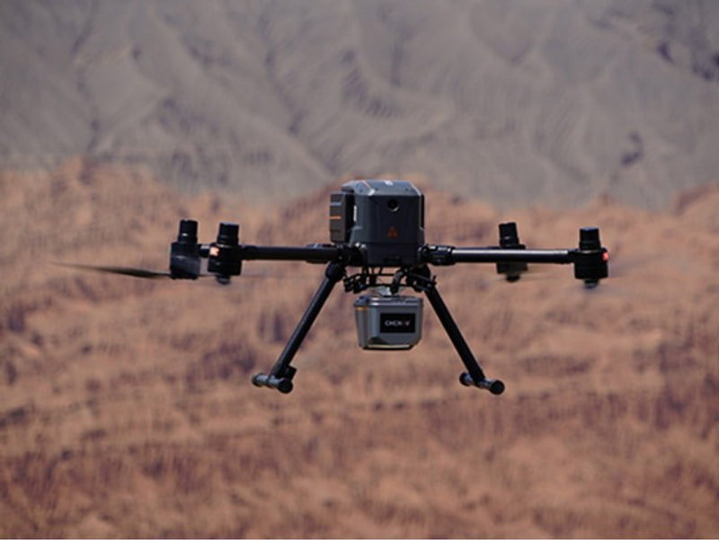
CHCNAV X500 and AlphaAir 9: Redefining Aerial Mining Surveys
One of the most powerful technologies available for mining applications today is drone-based LiDAR mapping. The CHCNAV X500 UAV combined with the AlphaAir 9 LiDAR system enables rapid collection of highly accurate terrain data over large mining sites.
The system captures dense three-dimensional point clouds, allowing surveyors to generate detailed topographic maps, monitor excavation progress, calculate stockpile volumes, and support mine planning activities with greater efficiency. Even in heavily vegetated or rugged terrain, LiDAR technology provides accurate terrain information that supports better operational decisions.
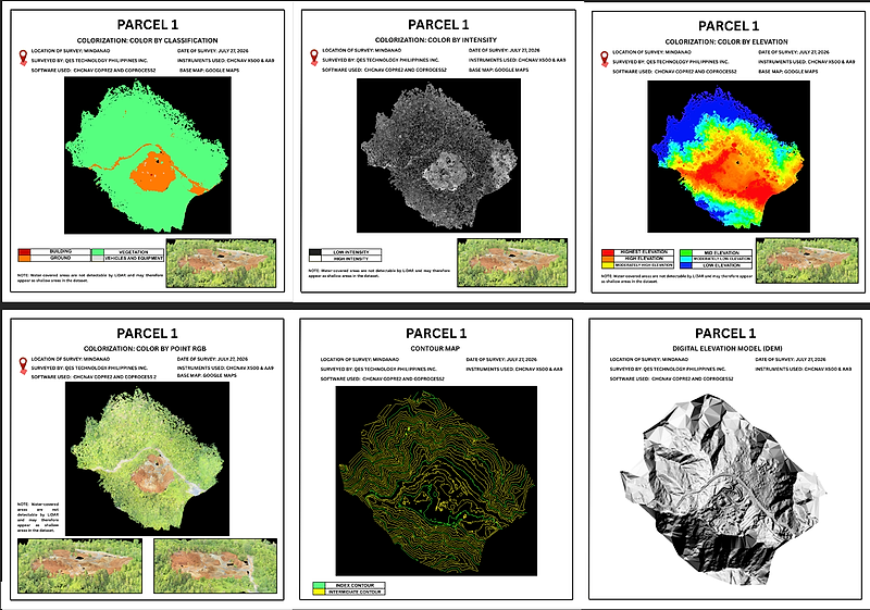
CHCNAV X500 AND AA9 SAMPLE OUTPUT MAPS
The maps shown were generated using the CHCNAV X500 and AA9 LiDAR SYSTEM, demonstrating the capability to produce accurate and detailed geospatial data for mining and surveying applications. The outputs include classification maps, intensity maps, elevation models, RGB orthomosaics, contour maps, and Digital Elevation Models (DEM), providing comprehensive terrain analysis and visualization. These deliverables support mine planning, stockpile monitoring, topographic surveying, site assessment, and informed decision-making through high-resolution and reliable spatial information.
Key Outputs:
Classification Map – Identifies and categorizes terrain features such as ground, vegetation, and structures.
Intensity Map – Displays LiDAR return intensity for enhanced surface interpretation.
Elevation Map – Visualizes terrain height variations across the survey area.
RGB Point Cloud – Provides realistic colorized representation of the surveyed site.
Contour Map – Illustrates terrain shape and elevation changes through contour lines.
Digital Elevation Model (DEM) – Delivers detailed terrain information for analysis, planning, and volume computations.
These outputs enable mining professionals to enhance operational efficiency, improve site understanding, and support data-driven decision-making.
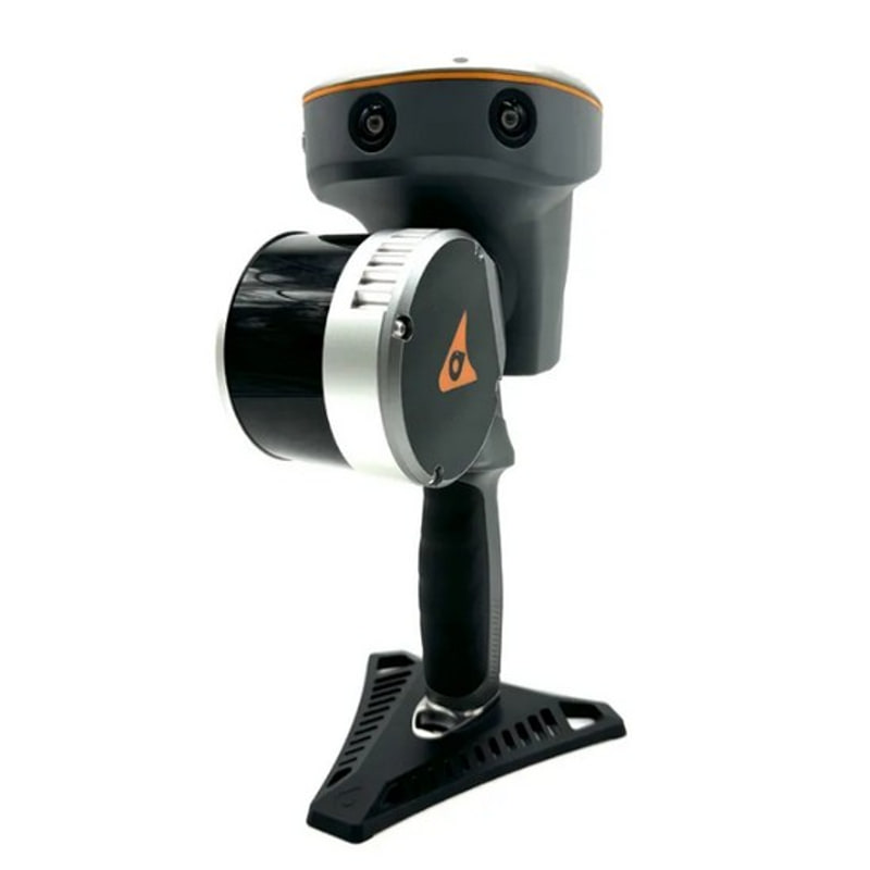
CHCNAV RS10: Accelerating 3D Reality Capture
As mining facilities become larger and more complex, the need for accurate digital documentation continues to grow. The CHCNAV RS10 Mobile Laser Scanner combines SLAM technology with GNSS RTK positioning to deliver seamless indoor and outdoor 3D mapping. Whether documenting stockpiles, processing plants, tunnels, or infrastructure, the RS10 allows users to rapidly capture georeferenced point cloud data with minimal setup requirements. The result is faster data collection, reduced field time, and enhanced operational planning capabilities
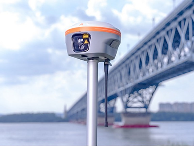
CHCNAV i85: Precision Positioning for Mining Professionals
Accurate positioning remains essential in mining operations. The CHCNAV i85 GNSS RTK receiver delivers centimeter-level accuracy while incorporating advanced IMU technology and laser measurement capabilities. For mining surveyors, this means faster data collection and the ability to safely measure difficult or inaccessible points without compromising accuracy. From mine planning and volumetric surveys to engineering layout and ground control establishment, the i85 provides the precision required by modern mining operations.
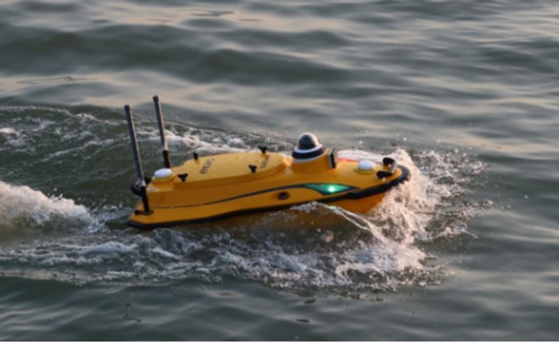
CHCNAV Apache 3 Pro: Smart Hydrographic Surveying
Effective water management is critical in mining. Tailings ponds, settling basins, and reservoirs require regular monitoring to support environmental compliance and operational efficiency.
The CHCNAV Apache 3 Pro Unmanned Surface Vessel (USV) enables autonomous hydrographic surveys while minimizing personnel exposure to water-related risks. Equipped with GNSS RTK positioning and bathymetric survey capabilities, the system provides accurate underwater terrain and depth data for a wide range of mining applications.
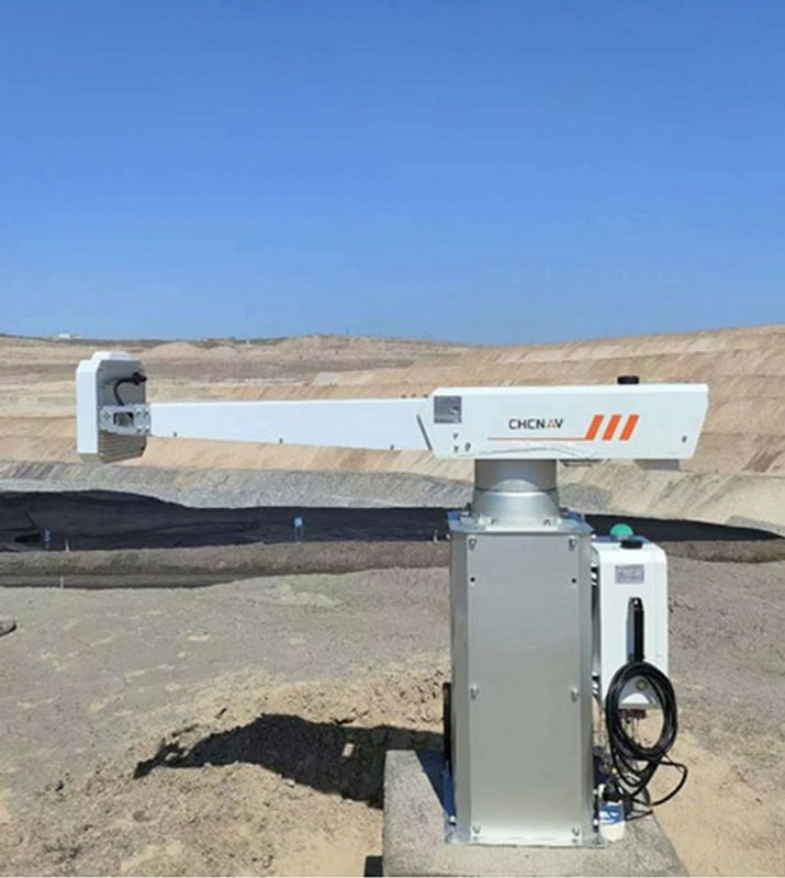
CHCNAV PS2000: Strengthening Mine Safety
Slope monitoring has become one of the most important aspects of modern mining safety programs. The CHCNAV PS2000 Ground-Based Radar is designed to continuously monitor slopes, highwalls, and critical mining infrastructure for signs of ground movement.
By providing real-time deformation monitoring and early warning capabilities, the PS2000 helps mining operators proactively identify potential hazards before they become critical safety issues. This contributes to safer mining operations and improved risk management strategies.

About GeoMate GNSS Solutions
Founded in 2018, GeoMate Positioning is a Singapore-based provider of premium surveying technologies. Its advanced GNSS receivers deliver high-precision positioning for mining, construction, and geospatial applications, featuring multi-constellation satellite tracking, RTK performance, and rugged field-ready designs.
For mining operations, GeoMate GNSS solutions enable accurate surveying, stockpile measurements, mine site mapping, and infrastructure monitoring, helping professionals improve productivity, efficiency, and decision-making in the field. Through QES Technology Philippines Inc., customers benefit from local technical support, training, and after-sales service.
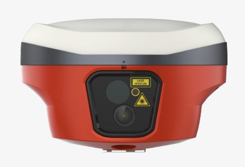
GEOMATE SG6L: Smart GNSS Surveying for Mining
The GeoMate SG6L Pocket Laser IMU-RTK Receiver combines high-precision GNSS positioning, laser measurement, IMU tilt compensation, and dual-camera technology in a compact, field-ready solution. Designed for demanding mining environments, it enables fast and accurate data collection while improving safety and productivity in the field.
Ideal for mine site mapping, stockpile measurements, and topographic surveys, the SG6L helps mining professionals capture reliable data, even in hard-to-reach areas.
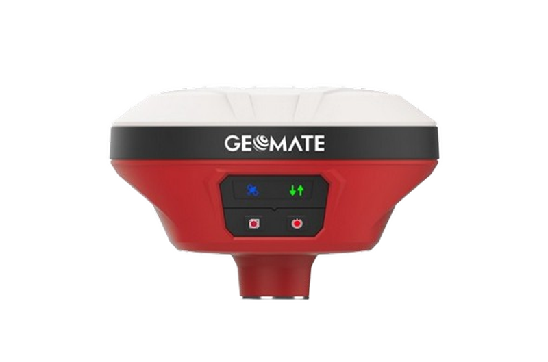
GEOMATE SG5: Reliable High-Precision GNSS Performance
The GeoMate SG5 is a premium 1608-channel IMU-RTK GNSS receiver designed in Singapore to deliver exceptional accuracy, performance, and reliability for demanding surveying and mining applications. Its advanced GNSS and IMU technology enables efficient and precise data collection in the field.
Ideal for mine site surveys, stockpile measurements, topographic mapping, and infrastructure development, the SG5 helps mining professionals improve productivity while maintaining centimeter-level positioning accuracy.
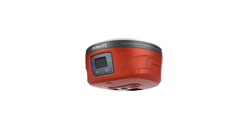
GEOMATE GBASE: Ultra-Long Range GNSS Base Station
The GeoMate GBASE is an ultra-long-range GNSS base station engineered to provide reliable RTK corrections for high-precision surveying and mining operations. Designed for demanding field environments, it delivers consistent performance with over 13 hours of continuous operation through its LongRun technology and advanced data compression capabilities.
Ideal for mine site mapping, monitoring, and large-scale survey projects; the GBASE ensures stable and accurate positioning data, helping survey teams maximize productivity and operational efficiency.
QES Technology Philippines: Your Trusted CHCNAV and GeoMate Partner
Technology delivers the greatest value when backed by expertise, training, and dependable support. As a trusted provider of CHCNAV and GeoMate solutions in the Philippines, QES Technology Philippines Inc. offers more than just industry-leading products. The company provides technical consultation, product demonstrations, user training, and comprehensive after-sales support to help clients maximize their investment and achieve optimal results in the field.
With a commitment to delivering innovative geospatial solutions for the mining industry, QES helps organizations improve productivity, enhance operational efficiency, and strengthen workplace safety through advanced positioning, surveying, mapping, and monitoring technologies from CHCNAV and GeoMate.
As mining companies continue to embrace digital transformation, QES remains dedicated to serving as a reliable partner by providing the tools, technical expertise, and support needed for long-term success. Through its portfolio of world-class CHCNAV and GeoMate solutions, QES empowers mining professionals to make smarter decisions, streamline operations, and build a safer and more sustainable future.
CHCNAV and GeoMate products are readily available through QES Technology Philippines, Inc. For product inquiries, demonstrations, technical consultations, and purchasing assistance, customers may contact our team by phone or email. QES is committed to delivering responsive service, reliable support, and fast access to industry-leading geospatial technologies, assuring you our best, always!